


Shapefile over Map (Demo)
Описание Shapefile over Map (Demo)
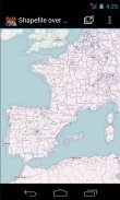
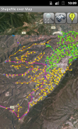
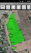
Load your own shapefiles with this Geographic Information System (GIS) directly from the sdcard of your mobile device and visualize them over a map. You can also edit the values of its dbf table and use it in offline mode, loading maps from your memory card.
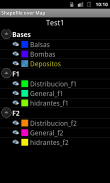
With this GIS application, you can select and load a shp file or load an entire folder automatically.
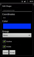
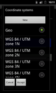
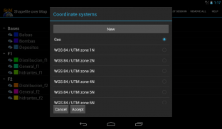
You can select one of these shp files and mark it as the active layer and if you do a long press over one of them you can change its coordinate system, its color or make it invisible.
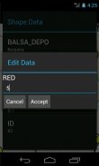
The map will display a series of icons, belonging to each of the records in the active layer, which when pressed will allow you to view and edit information from its corresponding attribute table.
The application also allows you to view your current position via GPS and center the map on it.
You can choose between several online map servers.
This is a demo version, some functionalities are only available in the full version.
Загрузите свои собственные шейпфайлы с этой географической информационной системы (ГИС) непосредственно из SDCard вашего мобильного устройства и визуализировать их на карте. Вы также можете редактировать значения его DBF таблицы и использовать его в автономном режиме, загрузка карт с карты памяти.
С помощью этого приложения ГИС, вы можете выбрать и загрузить файл SHP или автоматически загружать целую папку.
Вы можете выбрать один из этих SHP файлов и пометить его в качестве активного слоя, и если вы длительное нажатие на одну из них вы можете изменить свою систему координат, ее цвет или сделать его невидимым.
Карта будет отображать ряд иконок, относящихся к каждой из записей в активном слое, который при нажатии позволит просматривать и редактировать информацию из соответствующей таблицы атрибутов.
Приложение также позволяет просматривать текущее местоположение с помощью GPS и в центре карты на нем.
Вы можете выбрать между несколькими серверами интернет-карты.
Это демо-версия, некоторые функциональные возможности доступны только в полной версии.
Load your own shapefiles with this Geographic Information System (GIS) directly from the sdcard of your mobile device and visualize them over a map. You can also edit the values of its dbf table and use it in offline mode, loading maps from your memory card.
With this GIS application, you can select and load a shp file or load an entire folder automatically.
You can select one of these shp files and mark it as the active layer and if you do a long press over one of them you can change its coordinate system, its color or make it invisible.
The map will display a series of icons, belonging to each of the records in the active layer, which when pressed will allow you to view and edit information from its corresponding attribute table.
The application also allows you to view your current position via GPS and center the map on it.
You can choose between several online map servers.
This is a demo version, some functionalities are only available in the full version.
Shapefile over Map (Demo) - Версия 3.1
(28-03-2018)Shapefile over Map (Demo) - Информация об APK
Версия APK: 3.1Пакет: com.dabebro.somdemoПоследняя версия Shapefile over Map (Demo)


Приложения в этой категории

Вам также могут понравиться...


